Hello everybody
this is my first post and i hope you find it useful
Seismic is the most important tool for geologist to visualize the earth
Seismic
"Seismic" (size-mik) is one of the most important tools available to the Petroleum Geologist. It is a method used to determine the depth and orientation of rock formations without actually having to drill a well.
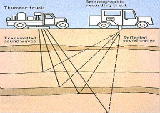
Although the principles of seismic are extremely complicated, it can be explained rather easily. Look at the diagram to the right.
A "source" of energy is applied at the surface of the ground. This energy may be applied by a "thumper" truck, which uses a large, heavy iron plate to strike the ground. More likely, the source will be dynamite, placed in a shallow hole and exploded.
Sound waves from the source travel down into the ground and are reflected back by the rock layers back up to the surface. A system of listening microphones or "geophones" picks up the reflected sound waves. The simple picture shows only one receiver. In practice, many such receivers are used. The more receivers used, the better the quality of the received data.

In a similar way, seismic data can be acquired for the sea floor and the rock layers beneath the sea.
To do this, a ship at sea tows a seismic source behind it. The seismic source provides very strong waves of sound energy (supplied by blasts of compressed air from air guns towed behind the ship) that penetrate the sea floor, bounce off the rock layers, and are then picked by hydrophones (listening devices located on the streamer) towed behind the ship. The seismic is then processed the same way as land seismic, and the result looks like the "line" of seismic shown below.
To do this, a ship at sea tows a seismic source behind it. The seismic source provides very strong waves of sound energy (supplied by blasts of compressed air from air guns towed behind the ship) that penetrate the sea floor, bounce off the rock layers, and are then picked by hydrophones (listening devices located on the streamer) towed behind the ship. The seismic is then processed the same way as land seismic, and the result looks like the "line" of seismic shown below.

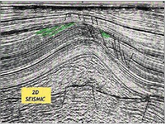
Once the data has all been "shot", the information is fed into computers for processing. The result is a "line" of seismic, shown below. Layers of rock deep in the earth can be clearly seen. On this "2D" line, stratigraphic traps containing possible oil or gas have been shaded green. The line is called "2D", or two-dimensional seismic, because it shows a single cross-section through the earth along a relatively straight line.


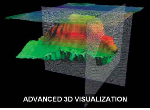
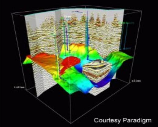
In the 1990's a new method of shooting seismic became popular. This was called "3D" seismic. "3D" seismic is shot much the same way as 2D except that the "shot points", or dynamite holes, are much closer together and are laid out on a grid, instead of in a straight line. The geophones that receive the reflected sound waves are also laid out in a grid. A huge amount of data is collected, and this data is processed by powerful computers. The result is a "3D data set" that can be manipulated on a computer to display fantastic three-dimensional images of the rock formations deep underground.
You might think that 3D seismic would solve all the problems of the petroleum geologist. It's not quite that simple. First of all, 3D seismic is extremely expensive. Second, 3D seismic is good at showing structural traps but not so good at showing stratigraphic traps. Finally, 3D seismic cannot help the PG tell if the rocks contain oil or gas. Only by drilling a well can this be established.
You might think that 3D seismic would solve all the problems of the petroleum geologist. It's not quite that simple. First of all, 3D seismic is extremely expensive. Second, 3D seismic is good at showing structural traps but not so good at showing stratigraphic traps. Finally, 3D seismic cannot help the PG tell if the rocks contain oil or gas. Only by drilling a well can this be established.


