GEOSCIENCE

هل تريد التفاعل مع هذه المساهمة؟ كل ما عليك هو إنشاء حساب جديد ببضع خطوات أو تسجيل الدخول للمتابعة.


+5
abdovolcano
uno
takey
mohammed radwan
salheen
9 مشترك

    مجله المنتدي بسرعه الحق حط موضوع وشارك وتميز

    salheen
    salheen
    المشرف العام
    المشرف العام


    ذكر عدد الرسائل : 286
    العمر : 36
    Localisation : nasr city
    university : Ain Shams
    تاريخ التسجيل : 12/07/2007

    مجله المنتدي بسرعه الحق حط موضوع وشارك وتميز Empty مجله المنتدي بسرعه الحق حط موضوع وشارك وتميز

    مُساهمة من طرف salheen 2007-10-23, 12:55 am

    بسم الله الرحمن الرحيم
    كما عودناكم دائما بالجديد والمزيد
    والتطور السريع للمنتدي
    الان سوف نشق طريقنا الي عالم الواقع
    ونخترق كل حدود الشبكه العنكبوتيه
    لنصل الي يد وعقل كل من له عين تقرأ
    اليوم والحمدلله اعلن افتتاح التجهيزات
    لاول مجله لموقعنا المنطلق بسرعه الصاروخ
    حيث قد جائنا البيان التالي
    تم الاتفاق مع قسم الجيوفيزياء بكليه العلوم جامعه عين شمس
    عن دعم مجله الموقع
    والان سوف اعلن لكم عن شروط الاشتراك بها
    اولا المجله سوف تكون مختصه بالجيوسينس كما عهدنا دائما
    ولكن نظرا لان الراعي الرسمي لها هو قسم الجيوفيزياء فسوف تفضل الموضوعات
    المختصه والمتعلقه بالجيوفيزياء عن الجيولوجيا نوعا ما
    مثال علي ذلك يفضل في الجيولوجيا مثلا الصخور الرسوبيه لما لها من اهميه لكل الجيوفيزيائين في دراستهم
    عن الحفريات
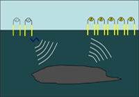
    وطبعا الطرق السيزميه والمغناطيسيه والبتروفيزيائيه وغيرها
    يجب الا تزيد الموضوعات عن صفحتين والا تقل عن صفحه
    وذلك لوضع اكبر عدد ممكن من الموضوعات
    مع اختيار موضوع رئيسي سيكون موضوع العدد
    سوف يناول باستفاضه
    وعند كتابه موضوع يجب كتباته في شكل شيق وبسيط وجميل
    وينتهي عند نقطه معينه مشوقه بحيث من يريد الاستزياد منه
    يذهب الي الموقع (وهذا هو ما يهمنا طبعا)
    طبعا المواضيع يفضل ان تكون بالانجليزيه
    وتسلم في موعد اقصاه من 7-10 ايام
    وذلك طبعا كي نستطيع تخليصها قبل الانشغال بالامتحانات العمليه والنظريه
    وسوف نحاول عمل نسخه الكترونيه ترسل الي ايميلات الاعضاء ان شاء الله
    وتوضع المواضيع في هذا الموضوع منعا للتكرار بين الاعضاء
    بالتوفيق يا شباب وياريت الهمه في ارسال المواضيع مبكرا
    وكل من يريد المشاركه يرسل لي الاسم بالكامل والجامعه والقسم والايميل
    لكي توضع اسفل موضوعه
    اعتقد ان اللى هيكتب موضوع هيستفاد كتير برده
    حتي نخرج المجله في احسن شكل يليق بنا ويشرفنا
    ودمتم في رعايه الله جميعا
    mohammed radwan
    mohammed radwan
    مراسل المنصورة
    مراسل المنصورة


    ذكر عدد الرسائل : 353
    العمر : 35
    Localisation : mansoura
    Emploi : 3rd geophysics studient
    university : mansoura
    تاريخ التسجيل : 28/08/2007

    مجله المنتدي بسرعه الحق حط موضوع وشارك وتميز Empty رد: مجله المنتدي بسرعه الحق حط موضوع وشارك وتميز

    مُساهمة من طرف mohammed radwan 2007-10-25, 9:24 pm

    بص يا عم صالحين
    انتا راجل جامد الحقيقه
    لكن الحكايه محتاجه دراسه شويه
    يا ريت لو نتقابل كلنا ف الجيو شات وحدد الميعاد
    بس ارجو ان كل الاعضاء يكونوا موجودين
    وبالذات كل الدماغات الجيوفيزيكس
    وبالذات
    moony
    takey
    darsh
    hosney
    عكروت
    و
    uno طبعا

    اهم حاجه يكون في اي يوم نكون فيه كلنا فاضيين

    بس ياريت يكون اي يوم بعد الساعه 6 وحياتي عندك اصل برجع م الكليه ف الوقت ده

    ارجو انك تظبط الموضوع ده انتا بقي

    وتشكر يا باشا
    avatar
    takey
    جيو صاعد
    جيو صاعد


    ذكر عدد الرسائل : 41
    العمر : 38
    Emploi : Geophysicist
    university : Mansoura
    تاريخ التسجيل : 07/10/2007

    مجله المنتدي بسرعه الحق حط موضوع وشارك وتميز Empty رد: مجله المنتدي بسرعه الحق حط موضوع وشارك وتميز

    مُساهمة من طرف takey 2007-10-26, 12:37 am

    ok ,
    I'm free after 8:00,"normally "
    Smile
    salheen
    salheen
    المشرف العام
    المشرف العام


    ذكر عدد الرسائل : 286
    العمر : 36
    Localisation : nasr city
    university : Ain Shams
    تاريخ التسجيل : 12/07/2007

    مجله المنتدي بسرعه الحق حط موضوع وشارك وتميز Empty رد: مجله المنتدي بسرعه الحق حط موضوع وشارك وتميز

    مُساهمة من طرف salheen 2007-10-26, 2:27 am

    يا شباب
    عايزين يوم الجمعه بعد الصلاه مثلا
    salheen
    salheen
    المشرف العام
    المشرف العام


    ذكر عدد الرسائل : 286
    العمر : 36
    Localisation : nasr city
    university : Ain Shams
    تاريخ التسجيل : 12/07/2007

    مجله المنتدي بسرعه الحق حط موضوع وشارك وتميز Empty رد: مجله المنتدي بسرعه الحق حط موضوع وشارك وتميز

    مُساهمة من طرف salheen 2007-10-26, 3:46 am

    بسم الله نفتتح اول موضوع في المجله
    الموضوع مقدم من العضو

    can u do logging before drilling.......we can
    !!!!!!!!!
    Multi-Transient EM – an overview
    Would you like to have the opportunity to acquire resistivity profiles identifying hydrocarbons in your subsurface area of interest - be it onshore or offshore - before the rig is even moved on site?

    Well, it's now possible, using the Multi-Transient EM (Electromagnetic) technique developed by MTEM.
    Multi-Transient EM is essentially Logging Before Drilling technology with the potential to transform the process of detecting and quantifying hydrocarbons in the subsurface.

    The MTEM technique entails injecting an electrical transient - or step - current into the subsurface and measuring the voltage response between pairs of receiver electrodes along the recording line; the process is repeated multiple times to acquire a detailed lateral and vertical profile. MTEM's novel application of a broadband signal enables recording of a continuous frequency spectrum dataset. The source and receiver response is removed from the data via deconvolution, yielding the impulse response of the earth; signal processing techniques are used to produce a resistivity cross section. Given that hydrocarbon-bearing rocks are known to show increased resistivity, the zones that appear highly resistive may indicate the presence of hydrocarbons. For the first time, it's possible to acquire this resistivity profile prior to drilling rather than conventional resistivity data acquired post/during drilling.


    EXPLORATION using MTEM
    Given its sensitivity to fluid types contained within the rock, Multi-Transient EM is the ideal tool for regional reconnaissance and initial exploration efforts in new play as well as frontier areas. It can be used to high-grade exploration prospects and has the added advantage of being environmentally friendly owing to its small footprint.


    مجله المنتدي بسرعه الحق حط موضوع وشارك وتميز Green210
    مجله المنتدي بسرعه الحق حط موضوع وشارك وتميز Shot2310

    Multi-Transient Electromagnetic (MTEM) Applications are Wide-Ranging
    Multi-Transient EM is an innovative, unique geophysical technology having the ability to determine subsurface resistivity in un-drilled areas. The MTEM method entails transmitting a series of pulse-coded electrical transient signals into the earth and measuring the voltage response between pairs of receiver electrodes along the recording line at different offsets, or distances, from the source. Because the hydrocarbon-bearing rocks are known to show increased resistivity, the subsurface zones that appear highly may resistive indicate the presence of hydrocarbons.

    Multi-Transient EM application yields an array of benefits, including:


    Direct Hydrocarbon Indicator
    Lower risk drilling decisions
    Identify by-passed pay
    Correlates directly with well data
    Identify and estimate reserves

    Given MTEM's ability to produce resistivity profiles over prospective reservoirs - prior to drilling - the technology is particularly valuable as a means to dramatically reduce the risk of drilling dry holes. In fact, MTEM is commonly referred to as Logging Before Drilling technology. MTEM is an invaluable tool for exploration as well as for field development and production. And it can be applied both onshore and offshore.

    Exploration Applications
    Applications include:


    Direct resistivity indicator
    Imaging through complex overburden
    Imaging resistors beneath seismic fault shadow
    Confirmation where AVO results are inconclusive
    Confirmation where Direct Hydrocarbon Indicators are inconclusive
    Imaging top resistor surfaces, such as carbonates

    by:islam henaish
    4th geology-geophysics department
    faculty of science
    ain shams university
    uno
    uno
    مراسل الاسكندرية
    مراسل الاسكندرية


    ذكر عدد الرسائل : 217
    العمر : 36
    Localisation : Alexandria
    Emploi : geochemistry student
    university : Alexandria
    تاريخ التسجيل : 15/06/2007

    مجله المنتدي بسرعه الحق حط موضوع وشارك وتميز Empty رد: مجله المنتدي بسرعه الحق حط موضوع وشارك وتميز

    مُساهمة من طرف uno 2007-10-26, 12:44 pm

    OK ya sal7een w ya geo-radwan
    ana mwafe2.. b3d l salah
    piece ya man
    lol!
    uno
    uno
    مراسل الاسكندرية
    مراسل الاسكندرية


    ذكر عدد الرسائل : 217
    العمر : 36
    Localisation : Alexandria
    Emploi : geochemistry student
    university : Alexandria
    تاريخ التسجيل : 15/06/2007

    مجله المنتدي بسرعه الحق حط موضوع وشارك وتميز Empty رد: مجله المنتدي بسرعه الحق حط موضوع وشارك وتميز

    مُساهمة من طرف uno 2007-10-26, 2:43 pm

    يا جماعه المعاد بتاع المقابلة اتغير لبكرة السبت الساعه عشرة مساءً بالاتفاق مع صالحين وجيو-رضوان نظرا لأن الوقت كان مش مناسب لبعض الناس ومش حضرو
    mohammed radwan
    mohammed radwan
    مراسل المنصورة
    مراسل المنصورة


    ذكر عدد الرسائل : 353
    العمر : 35
    Localisation : mansoura
    Emploi : 3rd geophysics studient
    university : mansoura
    تاريخ التسجيل : 28/08/2007

    مجله المنتدي بسرعه الحق حط موضوع وشارك وتميز Empty رد: مجله المنتدي بسرعه الحق حط موضوع وشارك وتميز

    مُساهمة من طرف mohammed radwan 2007-10-26, 4:56 pm

    اوك
    بس ياريت يا جماعه كل الجيوفيزيكس يكونوا موجودين
    ع فكره الموضوع اللي فوق ده جامد
    عايزين حاجات من دي ف المجله
    وانا متاكد يعني اننا مثلا لو اخدت اول عدد ووريته لاي دكتور عندنا هيكون مبهور ، وده هيعملنا صيت جامد ، لكن هيا محتاجه شويه شغل ، ياريت بس كله يكون موجود

    وانا شايف مثلا ان الجمعيه بتاعتك يا صالحين هتفيدنا كتير ف الموضوع ده ، وعايزين برده خبره الناس اللي شغالين زي takey و marawan
    كده يعني
    abdovolcano
    abdovolcano
    جيو محترف
    جيو محترف


    ذكر عدد الرسائل : 240
    العمر : 36
    Localisation : alagamy alexandria
    Emploi : undergraduate geochemist
    university : alexandria
    تاريخ التسجيل : 12/09/2007

    مجله المنتدي بسرعه الحق حط موضوع وشارك وتميز Empty رد: مجله المنتدي بسرعه الحق حط موضوع وشارك وتميز

    مُساهمة من طرف abdovolcano 2007-10-27, 3:07 pm

    فكره جامده يا جماعه اتمنى اشارك بموضوع جيد
    hosny hassan
    hosny hassan
    جيو محترف
    جيو محترف


    ذكر عدد الرسائل : 68
    العمر : 36
    Localisation : alexandia, egypt
    university : geophysics departement
    تاريخ التسجيل : 12/09/2007

    مجله المنتدي بسرعه الحق حط موضوع وشارك وتميز Empty رد: مجله المنتدي بسرعه الحق حط موضوع وشارك وتميز

    مُساهمة من طرف hosny hassan 2007-10-27, 4:05 pm

    جميل أوي الحماس و انا حكون ان شاء الله أول المشاركين
    اتمنى لكم التوفيق و النجاح
    ان شاء الله النهارده انا حكون موجود
    Idea
    abdovolcano
    abdovolcano
    جيو محترف
    جيو محترف


    ذكر عدد الرسائل : 240
    العمر : 36
    Localisation : alagamy alexandria
    Emploi : undergraduate geochemist
    university : alexandria
    تاريخ التسجيل : 12/09/2007

    مجله المنتدي بسرعه الحق حط موضوع وشارك وتميز Empty رد: مجله المنتدي بسرعه الحق حط موضوع وشارك وتميز

    مُساهمة من طرف abdovolcano 2007-10-31, 7:06 pm

    the longest under ground river discovered

    Explorers in the Yucatán Peninsula have found what they believe may be the longest known underground river in the world. The system meanders through 95 miles of limestone caverns and has taken almost 4 years to map out.
    The water inside the system stays a constant 76 degrees Fahrenheit year-round and is also stratified. A thin lens of freshwater floats on top of salt water. British research and diver Stephen Bogaerts said that much of the water is not necessarily flowing through the system either, rather up to 98% of the water is locked within the limestone.


    مجله المنتدي بسرعه الحق حط موضوع وشارك وتميز Yucatanriver
    ممكن اشارك بالموضوع ده


    source from this site

    http://egypt-news.asfory.com/2007/03/02/longest-underground-river-found/


    عدل سابقا من قبل في 2007-11-02, 3:30 am عدل 2 مرات
    salheen
    salheen
    المشرف العام
    المشرف العام


    ذكر عدد الرسائل : 286
    العمر : 36
    Localisation : nasr city
    university : Ain Shams
    تاريخ التسجيل : 12/07/2007

    مجله المنتدي بسرعه الحق حط موضوع وشارك وتميز Empty رد: مجله المنتدي بسرعه الحق حط موضوع وشارك وتميز

    مُساهمة من طرف salheen 2007-10-31, 10:47 pm

    ماشي يا عبدو
    بس ياريت تحط المصدر بتاعك او لينك الموضوع وبياناتك بالظبط
    salheen
    salheen
    المشرف العام
    المشرف العام


    ذكر عدد الرسائل : 286
    العمر : 36
    Localisation : nasr city
    university : Ain Shams
    تاريخ التسجيل : 12/07/2007

    مجله المنتدي بسرعه الحق حط موضوع وشارك وتميز Empty رد: مجله المنتدي بسرعه الحق حط موضوع وشارك وتميز

    مُساهمة من طرف salheen 2007-11-01, 11:24 pm

    المواضيع فين يا شباب
    النهارده اخر يوم لتسليمها زي ما اتفقنا
    mohammed radwan
    mohammed radwan
    مراسل المنصورة
    مراسل المنصورة


    ذكر عدد الرسائل : 353
    العمر : 35
    Localisation : mansoura
    Emploi : 3rd geophysics studient
    university : mansoura
    تاريخ التسجيل : 28/08/2007

    مجله المنتدي بسرعه الحق حط موضوع وشارك وتميز Empty رد: مجله المنتدي بسرعه الحق حط موضوع وشارك وتميز

    مُساهمة من طرف mohammed radwan 2007-11-02, 12:36 am

    star age of 13.2 billion years
    we know that age of universe is 13.7 billion years

    now , scientists found star of 13.2 billion years

    How old are the oldest stars? Using ESO's VLT, astronomers recently measured the age of a star located in our Galaxy. The star, a real fossil, is found to be 13.2 billion years old, not very far from the 13.7 billion years age of the Universe. The star, HE 1523-0901, was clearly born at the dawn of time

    This technique is analogous to the carbon-14 dating method that has been so successful in archaeology over time spans of up to a few tens of thousands of years. In astronomy, however, this technique must obviously be applied to vastly longer timescales

    مجله المنتدي بسرعه الحق حط موضوع وشارك وتميز Phot-23a-07-preview
    the abundance of a radioactive (unstable) isotope decreases all the time. The faster the decay, the less there will be left of the radioactive isotope after a certain time, so the greater will be the abundance difference when compared to a stable isotope, and the more accurate is the resulting age.

    Yet, for the clock to remain useful, the radioactive element must not decay too fast - there must still be enough left of it to allow an accurate measurement, even after several billion years.

    Large amounts of these elements have been found in the star HE 1523-0901, an old, relatively bright star that was discovered within the Hamburg/ESO survey

    The star was then observed with UVES on the Very Large Telescope (VLT) for a total of 7.5 hours

    مجله المنتدي بسرعه الحق حط موضوع وشارك وتميز Phot-23b-07-preview
    they measure more than a single cosmic clock for a star
    use 6 elements
    they use vlt to measure radioactive elements
    "Actual age measurements are restricted to the very rare objects that display huge amounts of the radioactive elements thorium or uranium "said by anna frebel
    Ever since the star was born, these "clocks" have ticked away over the eons, unaffected by the turbulent history of the Milky Way. They now read 13.2 billion years.

    The Universe being 13.7 billion years old, this star clearly formed very early in the life of our own Galaxy, which must also formed very soon after the Big Bang.

    this resarch was done by
    Anna Frebel
    McDonald Observatory, Texas
    Norbert Christlieb
    Department of Astronomy and Space Physics, Uppsala University, Sweden
    source
    European Organisation
    for Astronomical
    Research in the
    Southern Hemisphere
    eso
    طبعا اكيد لسه هتظبط المواضيع دي ، يعني حرف ناقص
    تربط الجمل ف بعض
    كده
    بس الموضوع استرفيزكس
    abdovolcano
    abdovolcano
    جيو محترف
    جيو محترف


    ذكر عدد الرسائل : 240
    العمر : 36
    Localisation : alagamy alexandria
    Emploi : undergraduate geochemist
    university : alexandria
    تاريخ التسجيل : 12/09/2007

    مجله المنتدي بسرعه الحق حط موضوع وشارك وتميز Empty رد: مجله المنتدي بسرعه الحق حط موضوع وشارك وتميز

    مُساهمة من طرف abdovolcano 2007-11-02, 3:21 am

    اسمي بالكامل

    عبدالله ابراهيم عبد المنعم


    قسم جيو كيمياء السنه الرابعه


    e-mail:abdovolcano@hotmail.com


    عدل سابقا من قبل في 2007-11-08, 5:44 pm عدل 1 مرات
    avatar
    takey
    جيو صاعد
    جيو صاعد


    ذكر عدد الرسائل : 41
    العمر : 38
    Emploi : Geophysicist
    university : Mansoura
    تاريخ التسجيل : 07/10/2007

    مجله المنتدي بسرعه الحق حط موضوع وشارك وتميز Empty رد: مجله المنتدي بسرعه الحق حط موضوع وشارك وتميز

    مُساهمة من طرف takey 2007-11-02, 11:54 pm

    My friend can you download the attached file


    انا
    حاولت اضغط الموضوع اكتر من كدة بس ما عرفتش لو كبير اوى قولى اشيل منة حاجات


    http://www.savefile.com/files/1167279
    moony
    moony
    جيو محترف
    جيو محترف


    انثى عدد الرسائل : 77
    Localisation : alexandria
    Emploi : student
    university : alexandria university
    تاريخ التسجيل : 12/09/2007

    مجله المنتدي بسرعه الحق حط موضوع وشارك وتميز Empty رد: مجله المنتدي بسرعه الحق حط موضوع وشارك وتميز

    مُساهمة من طرف moony 2007-11-03, 11:12 pm

    hi salheen this is a topic abot seismic acquisition i hope u find it good

    http://www.mediafire.com/?7sytm3domnt

    name: El- shaymaa Mahmoud Fouad
    fourth year geophysics depatrment alexandria university


    عدل سابقا من قبل في 2007-11-04, 10:13 pm عدل 1 مرات
    mohammed radwan
    mohammed radwan
    مراسل المنصورة
    مراسل المنصورة


    ذكر عدد الرسائل : 353
    العمر : 35
    Localisation : mansoura
    Emploi : 3rd geophysics studient
    university : mansoura
    تاريخ التسجيل : 28/08/2007

    مجله المنتدي بسرعه الحق حط موضوع وشارك وتميز Empty رد: مجله المنتدي بسرعه الحق حط موضوع وشارك وتميز

    مُساهمة من طرف mohammed radwan 2007-11-03, 11:56 pm

    بص يا عم صالحين
    ده موضوعي
    سيبك بقي من موضوع النجوم زي ما اتفقنا

    http://www.savefile.com/files/1169455


    الاسم
    محمد رضوان محمود
    الفرقه الثالثه جيوفيزياء
    جامعه المنصوره
    salheen
    salheen
    المشرف العام
    المشرف العام


    ذكر عدد الرسائل : 286
    العمر : 36
    Localisation : nasr city
    university : Ain Shams
    تاريخ التسجيل : 12/07/2007

    مجله المنتدي بسرعه الحق حط موضوع وشارك وتميز Empty رد: مجله المنتدي بسرعه الحق حط موضوع وشارك وتميز

    مُساهمة من طرف salheen 2007-11-04, 1:35 am

    شكرا يا شباب علي المشاركه بس ياريت كل واحد يكتب ايميله واسمه وقسمه وجامعته بياناته يعني عشان حتحط جنب موضوعه
    hosny hassan
    hosny hassan
    جيو محترف
    جيو محترف


    ذكر عدد الرسائل : 68
    العمر : 36
    Localisation : alexandia, egypt
    university : geophysics departement
    تاريخ التسجيل : 12/09/2007

    مجله المنتدي بسرعه الحق حط موضوع وشارك وتميز Empty رد: مجله المنتدي بسرعه الحق حط موضوع وشارك وتميز

    مُساهمة من طرف hosny hassan 2007-11-04, 1:54 am

    بسم الله الرحمن الرحيم
    هذا الموضوع ان شاء الله سوف أشارك به في المجلة يا رب يعجبك يا صالحين
    هو عن 4D seismic technology
    http://mihd.net/7oln20
    name: hosny hassan moussa
    4th year geophysics
    faculty of science
    alexandria university
    hosny_diab@yahoo.com
    Very Happy


    عدل سابقا من قبل في 2007-11-06, 8:34 pm عدل 1 مرات
    salheen
    salheen
    المشرف العام
    المشرف العام


    ذكر عدد الرسائل : 286
    العمر : 36
    Localisation : nasr city
    university : Ain Shams
    تاريخ التسجيل : 12/07/2007

    مجله المنتدي بسرعه الحق حط موضوع وشارك وتميز Empty رد: مجله المنتدي بسرعه الحق حط موضوع وشارك وتميز

    مُساهمة من طرف salheen 2007-11-04, 11:30 pm

    موضوع الاخ والمشرف العزيز darsh
    موضوع اكثر من رائع وفكره جديده
    Botanical problems. studied by applied geophysics
    اضغط هنا
    mohammed radwan
    mohammed radwan
    مراسل المنصورة
    مراسل المنصورة


    ذكر عدد الرسائل : 353
    العمر : 35
    Localisation : mansoura
    Emploi : 3rd geophysics studient
    university : mansoura
    تاريخ التسجيل : 28/08/2007

    مجله المنتدي بسرعه الحق حط موضوع وشارك وتميز Empty رد: مجله المنتدي بسرعه الحق حط موضوع وشارك وتميز

    مُساهمة من طرف mohammed radwan 2007-11-05, 4:06 am

    انا مش فاهم المشكله في ايه يا صالحين ، في الملف نفسه ولا في الرفع

    عموما سيبك

    هوه ده الموضوع
    Failure of Korea nuclear test
    After a period of north Korea nuclear explosion , expert realize that the explosion is small energy , the nuclear explosion is measured by kilotons equal to explosion of thousands of tons of tnt , almost nuclear explosion was of nearly (5-25) kilo tons , trenty explosion in 1945 was of 20 kilotons , but Korea test was of 1/2 kilotons.
    Some said that there is no nuclear explosion, and the explosion for tnt , but there is radiation of xenon that gathered from air specimens , that means that there is nuclear explosion because xenon is a chemical elements come from nuclear reaction.
    In 9/10/2006 seismological sensors detect a quake of 4.2 and its center was north east Korea ,the president of korea said that they will do anuclear test , that make seismologists take attention because there is more that 20 quake of such energy was recoded in this area .
    These detectors said that this test fail because of the small energy
    As they know the geologic area they will differ between nuclear test and earthquakes ,firstly , nuclear explosion cause p.waves (pull push) but with high amplitudes in the first recording (high peaks in first ) , but for earthquakes ,amplitudes is small in first that hardly noticed and then increase in intensity (small peaks and the high peaks)
    Explosion donnot make s. waves from , but come because it cause twist of surroundings rocks and emit energy from it
    Geology also can trick us , for examples , p.waves can converted to s.waves whan move through dilatational surface ,and also volcanic tuff can cause stop of s.waves.
    مجله المنتدي بسرعه الحق حط موضوع وشارك وتميز 11tq3
    Note : this graph wasnot for korea explosion ,it is only the difference between nuclear , note that reliegh waves was recorded after small period of s.waves that means asmall depth
    This explosion of 4.2 degree ,that means 1/2 kilotons , that depends also on the physical properties of korea materials , the materiels of korea was granite gneiss that transport [color=white]seismic waves easily , but Iranian seek was different state , means that iran was tectonically active and seismic waves donnot move easily like north korea , and when the middle east effected by earthquakes , it is complex to differ earthquake from nuclear test in iran for example, due to this , the energy will be less than one kiloton for any test of iran.
    u.s.a failed due to this reason to detect 26 experiments of Russia in middle Asia , because the energy was less than one kiloton.
    now . there is a net of seismological instruments in middle east to not allow iran have nuclrear weapons ,this net belong to comprehensive nuclear test ban organization that have 170 station allover the world not allow making nuclear tests in secret.
    Source
    Scientific American magazine
    S. Simpson
    May-June 2007


    Mohammed radwan mahmoud
    Mansoura university
    3rd year geophysics
    لو عايز ارفعه تاني اوكي
    هوه مساحته صغيره جدا اصلا
    وتحياتي
    maalem basha
    maalem basha
    جيو صاعد
    جيو صاعد


    ذكر عدد الرسائل : 45
    العمر : 37
    Localisation : K.F.C
    university : الاسكندريه
    تاريخ التسجيل : 12/09/2007

    مجله المنتدي بسرعه الحق حط موضوع وشارك وتميز Empty رد: مجله المنتدي بسرعه الحق حط موضوع وشارك وتميز

    مُساهمة من طرف maalem basha 2007-11-08, 12:59 am

    أنا المعلم باشا من جامعه الاسكندريه و ده الموضوع بتاعى أتمنى أشوفه فى المجله

    The reservoirs


    Petroleum reservoirs:


    It is the part of the rock that contains the pool of oil and gas. Consist of:


    1) Reservoir rock (carrier) (collectors) 2) sealing rock (roof rock) 3) pore space which contain fluids (oil gas and water)


    1) Reservoirs rock (carrier) (collector)


    It is any rock contains connected pores. present in non-metamorphosed sedimentary rock . most of them in sandstone , limestone and dolomite.


    2) Roof rock (seal rock) (cap rock)


    In the case of salt dome roof rock is the impervious strata that over layers the reservoir rock. It is shale or other impervious rock that act as a barrier to the movement of oil and gas.


    Factor that affect it:


    · Thickness


    · Homogeneity

    · Permeability

    · Mineralogical composition


    3) Traps (reservoir traps)


    It is any barrier to the upward movement of oil and gas allowing either or both to accumulation.

    It is something that stops the upward migration of oil or gas and causes it to accumulate.

    The traps classified into 3 basin types:


    1) Structural traps:

    It is one whose upper boundary has been made concave as viewed from below by some local deformation such as folding or faulting or both of the reservoir rock.


    2) Stratigraphic traps:

    Is one in which the chief traps making element is some variation in the stratigraphic or litho logy or both of the reservoir rock.


    3) Combined traps:

    They are traps in the middle between structural and stratigraphic groups. They formed by both structural and stratigraphic causes in roughly equal proportions and called stratigraphic – structure traps.

    uno
    uno
    مراسل الاسكندرية
    مراسل الاسكندرية


    ذكر عدد الرسائل : 217
    العمر : 36
    Localisation : Alexandria
    Emploi : geochemistry student
    university : Alexandria
    تاريخ التسجيل : 15/06/2007

    مجله المنتدي بسرعه الحق حط موضوع وشارك وتميز Empty رد: مجله المنتدي بسرعه الحق حط موضوع وشارك وتميز

    مُساهمة من طرف uno 2007-11-08, 11:22 am

    عبدالرحمن محمد عارف
    الفرقة الثالثة
    جيولوجيا كيمياء
    igi_ypt@hotmail.com


    عدل سابقا من قبل في 2007-11-08, 12:54 pm عدل 1 مرات
    uno
    uno
    مراسل الاسكندرية
    مراسل الاسكندرية


    ذكر عدد الرسائل : 217
    العمر : 36
    Localisation : Alexandria
    Emploi : geochemistry student
    university : Alexandria
    تاريخ التسجيل : 15/06/2007

    مجله المنتدي بسرعه الحق حط موضوع وشارك وتميز Empty رد: مجله المنتدي بسرعه الحق حط موضوع وشارك وتميز

    مُساهمة من طرف uno 2007-11-08, 12:11 pm

    Seismic Data Applied to Subsurface Interpretation
    Introduction
    On a fundamental level, seismic data can provide two major benefits. First, seismic data can be acquired over areas that do not have any well data. The scond benefit is that seismic data can provide explicity 2D data as opposed to the 1D nature of wellbore.The data on the seismic line (seismic section) may actually represent a very complex 3D subsurface geologic world.
    Assumptions and Limitationsg
    to make a clear interpretation for an area, data used must be properly acquired and processed appropriately. some possible major problems include severe horizontal velocity gradient, high noise area, or an extremely complex geologic subsurface. all of which may invalidate many assumptions necessary for the acquisition of good data. If these problems are present, they may present a challenge for even the best geophysict. In such instances, the expertise of geophysict may be absolutely necessary to solve the complxities. Before totally discarding the use of geophysics in these areas, you should recognize that if geology is complex enough to cause these severe problems, it it is not going to be a trivial exercise to find the solution on well data alone. Even in these complex areas, seismic data may contain valuable information that can be used in creating a reasonable subsurface interpretation.
    The process
    The procedure for making subsurface maps using seismic data is very similar to the sequence of steps used in constructing interpretations from subsurface well log information. The first step is one of the DATA VALIDATION, i.e.. analysis of what the seismic data represent. Do the seismic data actually have some relationship to the geology in the subsurface? This procedure is similar to the checking one does when a log is first used. In the case of log data, desisions about the validity and meaning of the log response must be made before the data can be used to form an interpretation.
    The second step is the actual INTERPRETATION of the seismic section. This step is analogous to the correlation of well logs when using just subsurface well log information. Because the validity of the remaining work rests on having an accurate and geologically correct interpretation of the seismic data. this is the most important part of the process.
    The third step involves EXTRACTING THE INFORMATION from the seismic data and transferring it onto the map so that it can be used effectively. Usually, transferring the data to a map is referred to as posting. This procedure is practically indentical to that used when recording subsurface well log data. Since seismic sections have 2D aspect that well log data do not possess, there are some unique aspects to this step when using seismic data. This step also represents the merger of the subsurface and the seismic information. Both types of data should be posted and used to construct the final interpretation.
    An appeal is made to geophysicts as well as geologists. Very often, there are two sets of maps: the geological map and the geophysical map. A subsurface map should accurately represent the geology and both well logs and seismic data represent physical measurements of the subsurface. There is only one configuration of tdhe subsurface, and it is the job of the mapper to create an integrated and reconciled interpretation using all the data available.
    The last step is the CONSTRUCTION OF THE SUBSURFACE GEOLOGICAL MPAS. This step represents the culmination of the previously work, and in many instances will be the result by which your work is measured. It is only as good as the information it contains, so do not rush to begin this step before th previous steps are completely finished.
    In practice, though, this is never the last step. Several iterations of validation, interpretation, posting, and mapping are typically necessary before a satisfactory subsurface map is completed.
    At some point it will become apparent that most of the major questions have been resolved and a satisfactory map has been made. While pride and satisfaction in the result is deserved, always keep in mind that additional data from either drilling or addiltional seismic shooting will almost always change some of your ideas. These changes may be small, but subsurface mappping can never perfectly represent the structural configuration of the earth. The more your ideas are actually tested, the more obvious it becomes that mapping is both art and science. Ideally, you will asymptotically approch the truth as more data become available. The measure of an interpreter is his or her ability to approch the truth quickly with the limited data available.

      مواضيع مماثلة

      -

      الوقت/التاريخ الآن هو 2024-05-19, 6:41 pm